


2930470 - THE JUG Voting District, Upson County, Georgia
About
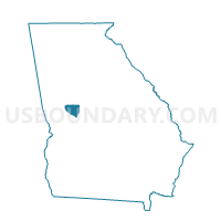
Outline

Summary
| Unique Area Identifier | 563026 |
| Name | 2930470 - THE JUG Voting District |
| County | Upson County |
| State | Georgia |
| Area (square miles) | 43.74 |
| Land Area (square miles) | 43.50 |
| Water Area (square miles) | 0.24 |
| % of Land Area | 99.45 |
| % of Water Area | 0.55 |
| Latitude of the Internal Point | 32.84919000 |
| Longtitude of the Internal Point | -84.20146680 |
Maps


Graphs
Select a template below for downloading or customizing gragh for 2930470 - THE JUG Voting District, Upson County, Georgia


Neighbors
Neighoring Voting District (by Name) Neighboring Voting District on the Map
- 0792 - DISTRICT 2 Voting District, Crawford County, GA
- 2930588 - YATESVILLE Voting District, Upson County, GA
- 2930589 - SALEM Voting District, Upson County, GA
- 2931577 - THE ROCK Voting District, Upson County, GA
- 2935610 - TOWN Voting District, Upson County, GA
Top 10 Neighboring County Subdivision (by Population) Neighboring County Subdivision on the Map
- Roberta CCD, Crawford County, GA (3,651)
- The Rock-Yatesville CCD, Upson County, GA (3,035)
- Salem CCD, Upson County, GA (1,367)
Top 10 Neighboring Unified School District (by Population) Neighboring Unified School District on the Map
Top 10 Neighboring State Legislative District Lower Chamber (by Population) Neighboring State Legislative District Lower Chamber on the Map
Top 10 Neighboring State Legislative District Upper Chamber (by Population) Neighboring State Legislative District Upper Chamber on the Map
Top 10 Neighboring 111th Congressional District (by Population) Neighboring 111th Congressional District on the Map
Top 10 Neighboring Census Tract (by Population) Neighboring Census Tract on the Map
- Census Tract 701, Crawford County, GA (3,651)
- Census Tract 101, Upson County, GA (3,035)
- Census Tract 106, Upson County, GA (1,367)